We are helping commercial transportation planners, logistics professionals, dispatchers and drivers visualize better routes, avoid costly delays, and deliver more loads.
Application Overview
Impact
About CRA
Future Prospects
OUr Team
contact us
As the COVID-19 pandemic has evolved, a patchwork of well-intentioned, state-level restrictions has emerged. Interstate commerce and the rapid delivery of critical food, medical and sanitation supplies has been impeded due to these restrictions. As commercial truckers and their employers work to move products across the country, they may encounter difficult logistics and restrictions. These include closed rest areas, local curfews, and in some cases, 14-day quarantines. In many cases, these restrictions are slowing the delivery of critical supplies at a time when they are needed most.
The DHS Cybersecurity and Infrastructure Security Agency (CISA) requested our expertise to provide a solution to help truckers and their employers navigate these quickly changing restrictions. Within one week, our team at Idaho National Laboratory (INL) deployed a prototype and demonstrated its effectiveness. Following a successful demonstration of the prototype, we rapidly designed, developed and deployed a capability for truckers and other commercial drivers in the U.S. to help them understand restrictions they may encounter as they travel across the country.
%
Percentage, measured by weight, of the nation's freight moved each year by commercial trucks.
Statistics from the American Trucking Association (ATA)
Millions of U.S. truck drivers who deliver the products that American consumers or businesses purchase each year.
Application Overview
The Commercial Routing Assistance (CRA) tool merges coordinated and vetted data streams, plots multiple automated or custom routing options, and visualizes the wide variety of state regulations and actions that a driver would encounter along a route. With the CRA, commercial operators can plan vehicle movements across multiple states quickly, particularly during emergencies.
CRA enables users to:
- View updated executive orders, declarations, curfews, social distancing, 14-day restrictions, and closings in multiple states in real-time
- Route commercial vehicles into or around various states in an efficient, compliant, and safe manner
- Access documentation drivers need on board the truck in case local law enforcement asks for it
- Ensures compliance with local and state laws and declarations in a changing dynamic transportation environment
- Utilize an efficient and easy to use centralized reliable data retrieval source
- Reduce “out of compliance” issues with state or local authorities that may resulting in fines or penalties
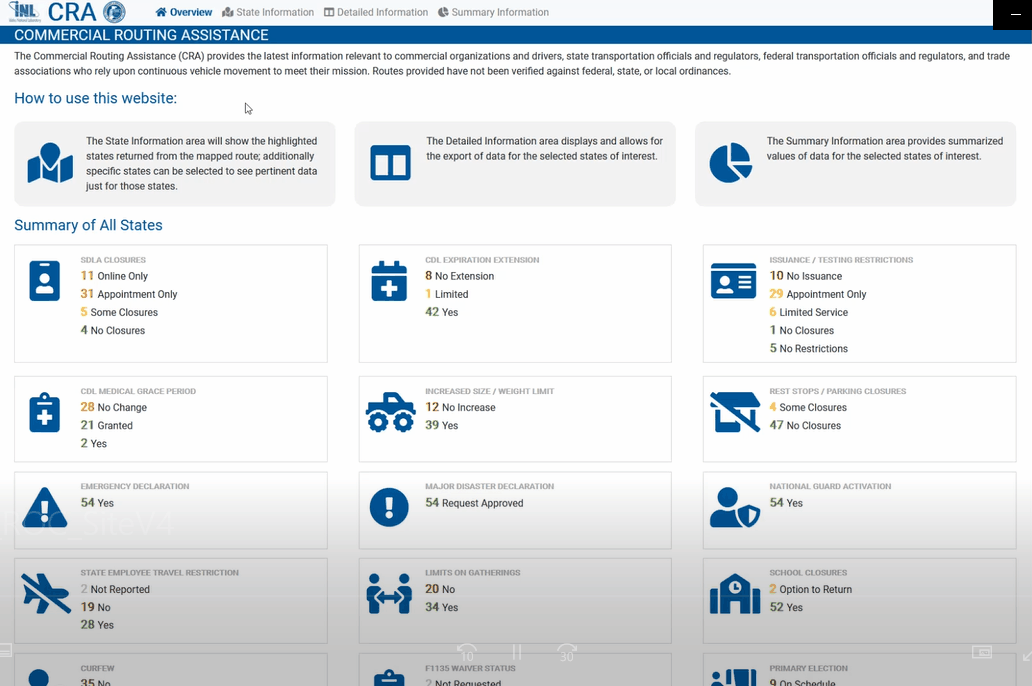
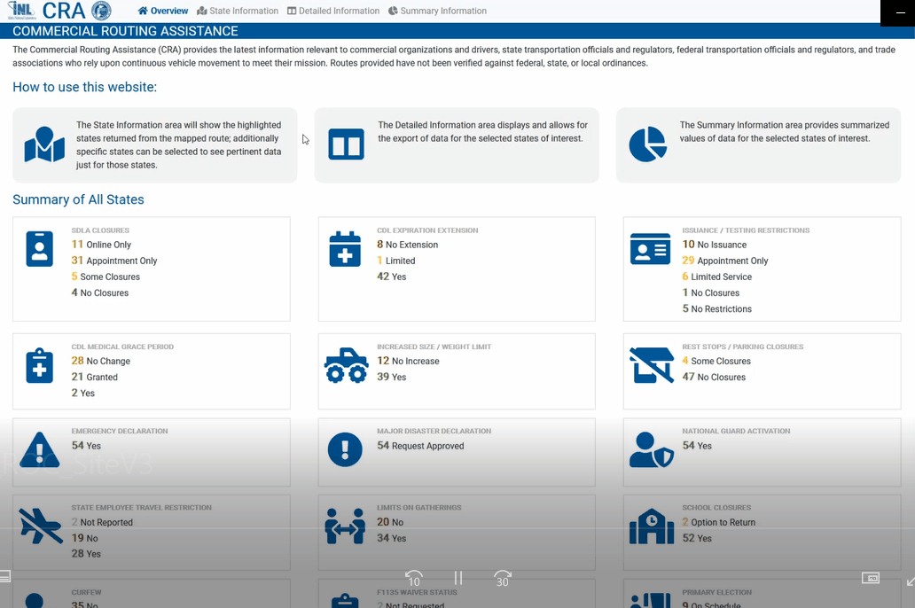
CRA Dashboard View
State-by-State Features
The CRA tool allows users to drill down into datasets within a specific state. For instance, a truck driver moving cargo from Los Angeles to New York may want to see the specific restrictions they’ll face in any of the 13 states they’ll pass through. The state-by-state map visualizes multiple layers of restrictions data with a stoplight color palette, showing states with the fewest restrictions for transporting cargo as green, and states with the most restrictions as red.
Below the state-by-state map is a reference chart that looks similar to a subway map. This chart displays up to 16 restriction feeds simultaneously. The restrictions range from expected conditions like curfews and quarantines, but also include more nuanced points like National Guard activations, limits on group gatherings or closures at state licensing facilities.
The spreadsheet and summary capabilities display state restriction data in formats that can be helpful for record keeping like expense audits or mileage logs. The spreadsheet feature also provides links to each individual state website where the source information for the maps originated, while the summary feature displays all the restrictions along a given route in a clean, single-page layout.
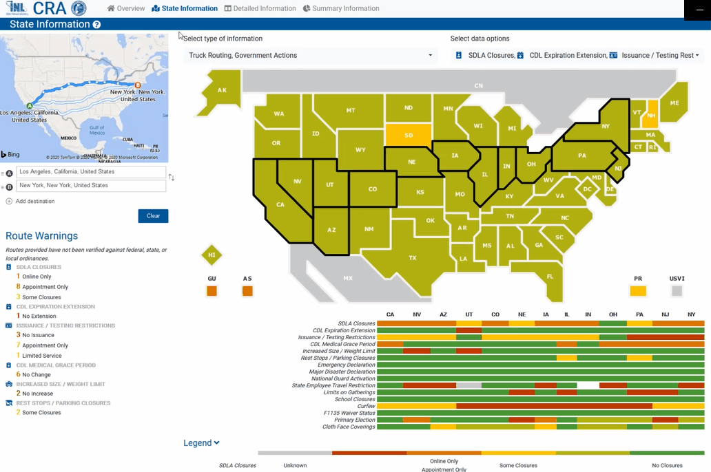
Mapping Tools and Functions
Like common mapping apps found on most smartphones and tablets, the INL CRA application allows users access to several key features to:
- Enter start and stop locations
- Populates with several potential routes, giving initial preference to the shortest route.
- Once the route is populated, users can see the state restrictions they may face along the way in a summary list next to the map.
- If users want to plan a custom route, they can simply drag and drop points on the route to go around a particular state.
- As map points are moved, the state restrictions are updated.
Impact
Essential resources that support nationally critical functions and missions are moved around the country by trucks and commercial vehicles during both steady-state and crisis/incident situations. Decisions and actions at the state and local level often dictate the ease with which these goods can be transported across boundaries. Particularly in the case of emergencies or disasters, a thorough understanding of the state-by-state variations of road closures, declarations, waivers, and load limits is important for operational decision makers and route planners for effective and efficient deployment of vehicles and delivery of vital supplies.
Support critical functions and missions by enabling operational decision makers and route planners
to effectively and efficiently deploy vehicles and deliver vital supplies.
About CRA
Working with the All Hazards Consortium (AHC), a 30,000-member public-private emergency response working group, INL researchers tapped into AHC’s Sensitive Information Sharing Environment (SISE) to coordinate and validate industry-relevant data streams. Using the SISE data models, INL created CRA in order to aid private and public transportation fleets in navigating across states with varying restrictions.
The request for this capability, and its subsequent rapid and successful development, reflects and strengthens the confidence held by CISA in the geospatial and critical infrastructure analysis capabilities of the National and Homeland Security Directorate of INL.
The AHC facilitates the SISE which is a legal framework that allows vetted public and private sector decision makers to view sensitive operational information. The CRA tools add a powerful new capability that can reduce the time it takes to get essential supplies wherever they are needed.


Future CRA Enhancements
Effective and efficient routing of fleet vehicles is vital, both in crises or in normal operations, saving costs to logistics companies and maintaining supply chains of essential resources. The CRA can be applied in many other contexts beyond pandemic response, from steady-state routing operations to planning and response efforts related to many types of major incidents:
- Inclement Weather
- Terrorism
- Earthquakes
Although the Commercial Routing Application was developed in response to the current COVID-19 pandemic, both DHS and INL see its potential for serving in other emergency response situations such as natural disasters that impact multiple states. For instance:
- Utility workers responding to downed power lines or damaged transformers following a hurricane or wildfire may need to route service trucks around state restrictions like disaster declarations or closed roads and bridges
- Adding information for drivers moving cargo into Canada or Mexico
- Adding crowdsourcing features that would collect and vet information in real-time from users out in the field
Already designed for use on multiple platforms including mobile devices, the CRA could soon benefit from real-time updates from drivers and dispatchers, who would submit reports of new closures, conditions, curfews, or other constraints, and from new data feeds and scales of analysis. Its current architecture allows for the integration of publicly available data streams, but future versions will, given access permissions, incorporate those that might be considered sensitive to business or national security.
Future capabilities may also include filters for routing that automate the planning of routes to avoid designated areas of travel restrictions. INL and its partners anticipate positive and constructive feedback from private and public sector operational users of the CRA and will be responsive and agile to the requirements and concerns of our stakeholders and industry partners.
Some of our Team
Tim Klett
Critical Infrastructure
Cybersecurity Analyst,
National and Homeland Security
Idaho National Laboratory
Robert Edsall
Geospatial Research and
Development Scientist,
National and Homeland Security
Idaho National Laboratory
Michael Overton
Geospatial Technology Development Lead, National and Homeland Security
Idaho National Laboratory
Mary Klett
Software Engineer,
National and Homeland Security
Idaho National Laboratory
Ollie Gagnon
Chief Strategist & Relationship Manager, National and Homeland Security
Idaho National Laboratory